
More About EOS . . .
• Travel directions to EOS
• EOS Overview [pdf]
• EOS Spheres Newsletters
• EOS Experts Guide [pdf]
"The terrestrial carbon cycle is a hot research area right now because of its connection to climate change and climate policymaking."
• EOS Overview [pdf]
• EOS Spheres Newsletters
• EOS Experts Guide [pdf]
"The terrestrial carbon cycle is a hot research area right now because of its connection to climate change and climate policymaking."
A Match Made in Carbon
Jingfeng Xiao is a perfect fit for the Complex Systems Research Center’s work in terrestrial carbon cycling
IT'S JUST COINCIDENCE that the Complex Systems Research Center’s newest faculty member replaces someone of the same namesake – Xiangming Xiao – but Jingfeng Xiao’s hire from Pennsylvania State University was very much calculated to mesh with and extend the reach of the center’s extensive work investigating the terrestrial carbon cycle.
The tools he brings to the job include remote sensing, ecological modeling, model-data fusion, and geographical information systems.
“I have a variety of interests and use different methods in my research so there’s a lot of overlap with other researchers in the center. Many of us, including myself, focus on the terrestrial carbon cycle and climate change,” Xiao says.
Notes CSRC colleague Steve Frolking, whose work includes investigating the role peatlands play in the carbon cycle, “Collectively the center has a very multidisciplinary approach so there’s great potential for collaboration, which is one reason why Jingfeng's name floated to the top of the list.”
Another reason for Xiao’s successful candidacy was that he was able to step in and fill the void created by the departure of research associate professor Rob Braswell, who left late last year to take a job in the private sector. At the time, Braswell was the principle investigator of a DOE-funded modeling project.
Because of his background and expertise Xiao was able to seamlessly take over the project, which serendipitously provides him funding for the next two years as he establishes himself at UNH.
A particular research interest for Xiao – and one that should lead to collaborative efforts with Complex Systems’ George Hurtt, Scott Ollinger, Frolking, Mary Martin, and others – is to better understand the impacts of climate variability and change, land use and land cover change, and disturbances (e.g., fire, hurricanes, insect defoliation) on the terrestrial carbon cycle.
“The terrestrial carbon cycle is a hot research area right now because of its connection to climate change and climate policymaking. Terrestrial ecosystems play an important role in regulating the atmospheric CO2 concentrations through photosynthesis, respiration, and the combustion of biomass,” Xiao says. He adds, “One of my main interests is to combine a variety of techniques to examine the magnitude, distribution, and mechanisms of the terrestrial carbon sinks and sources, particularly year-to-year variations, at regional to global scales.”
In other words, Xiao will bring additional expertise to the already substantial work within CSRC aimed at getting a clearer big-picture view of the terrestrial carbon cycle puzzle.
The atmosphere’s role in the carbon cycle is well measured and fairly well known, and as a result scientists have a fairly high degree of confidence in models that simulate climate change from an atmospheric perspective. However, there is less confidence in terrestrial numbers.
Of the terrestrial carbon budget Frolking says, “In the broad sense we know what’s going on but it’s the details we don’t understand. We don’t know deforestation that well, we don’t close the carbon budget well, we don’t know what CO2 fertilization effects are on vegetation productivity very well, and we don’t know the fate of high-latitude carbon with respect to permafrost.”
In a 2001 Science paper, Princeton University’s Stephen Pacala et al (George Hurtt and Berrien Moore were among the co-authors) estimated the magnitude of the carbon sink for the conterminous terrestrial ecosystem in the U.S. between 1980-89 to be 0.3-0.58 petagrams per year (a petagram equals about 2.2 trillion pounds). Notes Xiao, “What we’re trying to do is to better understand the relative and combined impacts of various factors such as warmer temperatures, increased precipitation, CO2 enrichment, extreme climate events, nitrogen deposition, ozone pollution, and disturbances on ecosystems and thus to reduce the uncertainties associated with these estimates.”
Unlike the atmosphere and the global ocean, which are both well-mixed fluids, the terrestrial biosphere doesn’t become homogenized. Thus, the variables that affect the carbon cycle in terrestrial systems can change a great deal from one spot to another.
For example, in a parcel of forest there is variation in soil minerals, roots, fungi, and decomposing plant litter and things often look different if you move to a spot just 50 feet away. And, says CSRC terrestrial ecologist Scott Ollinger, “There’s the imprint of disturbance and past land-use history, which also don’t get blended together as they would in air or water. And the result of all this creates a sampling problem. There’s a tremendous amount of complexity to account for and no one method offers a perfect solution.”
Which comes back to Xiao’s use of multiple approaches in his research. Among other projects, ongoing work of Xiao’s involves “upscaling” carbon flux measurements from eddy covariance flux towers across North America to the continental scale using wall-to-wall data gathered by the Moderate Resolution Imaging Spectroradiometer (MODIS) onboard NASA’s Terra and Aqua satellites and modeling approaches.
Eddy flux towers are micrometeorological stations that measure the turbulence or “eddies” of air above treetops for minute amounts of CO2, water vapor, and energy between the biosphere and the atmosphere. The only means of scaling up the data to look at variability across a continent is via remote sensing (like the MODIS imagery, for example, which gives continuous coverage over space and time), and/or through modeling.
Xiao’s efforts will help broaden the terrestrial carbon cycle picture and, in time, he plans to push the data to the global scale. “By quantifying the amount of carbon sequestered or released by ecosystems over regions, continents, or the globe we can better understand the feedbacks between the terrestrial biosphere and the atmosphere. This knowledge is essential for facilitating climate policymaking and projecting future climate change,” he says.
This will dovetail to some extent with another current effort aimed at policymaking – work being done by George Hurtt, who specializes in ecological modeling. Hurtt is lead investigator for a project aimed at using satellite data to reduce uncertainties in forest ecosystem modeling and, ultimately, improve policies crafted to mitigate climate change. NASA’s Terrestrial Ecology Program funds the project.
Central to Hurtt's project is the Ecosystem Demography Model (ED) he co-developed. For the project, ED will be coupled with a socio-economic model in an effort to simulate strategies for mitigating climate change, including strategies that involve biofuels and changes to wood production rates and usage under altered climate conditions.
“By combining ED with the economic model we can now explore with greater accuracy and process detail the potential for afforestation or bioenergy crop production to help stabilize atmospheric CO2,” Hurtt says.
Adds Ollinger, “Enacting policy in a meaningful way means we need good numbers. If a state or country is going to claim a certain amount of carbon credits because it protected some forestland, we need to know what the carbon budget of that forestland really is. Presently, the numbers we have are murky at best.”
Eventually, these efforts could lead to collaboration between EOS researchers and social scientists – something Xiao and others are hoping to explore. Such collaboration would be a required part of any attempt to predict future changes in land use and land cover – an enormously important part of the terrestrial carbon cycle but one that is equally difficult to address. -DS
The tools he brings to the job include remote sensing, ecological modeling, model-data fusion, and geographical information systems.
 |
|
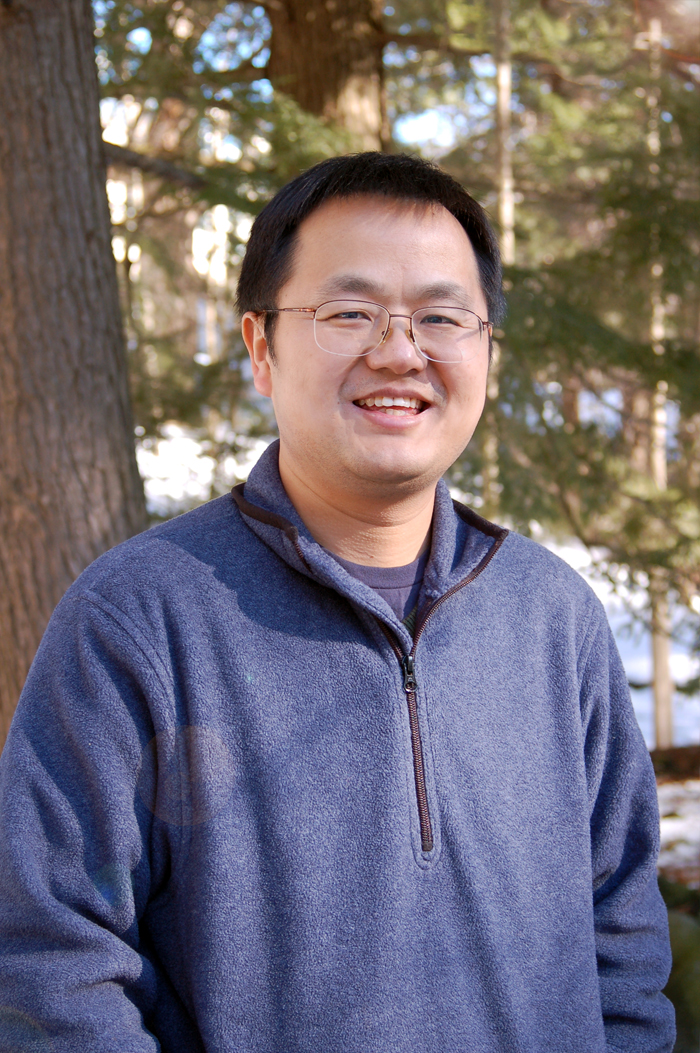
| Jingfeng Xiao Photo by K.Donahue, UNH-EOS |
Notes CSRC colleague Steve Frolking, whose work includes investigating the role peatlands play in the carbon cycle, “Collectively the center has a very multidisciplinary approach so there’s great potential for collaboration, which is one reason why Jingfeng's name floated to the top of the list.”
Another reason for Xiao’s successful candidacy was that he was able to step in and fill the void created by the departure of research associate professor Rob Braswell, who left late last year to take a job in the private sector. At the time, Braswell was the principle investigator of a DOE-funded modeling project.
Because of his background and expertise Xiao was able to seamlessly take over the project, which serendipitously provides him funding for the next two years as he establishes himself at UNH.
A particular research interest for Xiao – and one that should lead to collaborative efforts with Complex Systems’ George Hurtt, Scott Ollinger, Frolking, Mary Martin, and others – is to better understand the impacts of climate variability and change, land use and land cover change, and disturbances (e.g., fire, hurricanes, insect defoliation) on the terrestrial carbon cycle.
“The terrestrial carbon cycle is a hot research area right now because of its connection to climate change and climate policymaking. Terrestrial ecosystems play an important role in regulating the atmospheric CO2 concentrations through photosynthesis, respiration, and the combustion of biomass,” Xiao says. He adds, “One of my main interests is to combine a variety of techniques to examine the magnitude, distribution, and mechanisms of the terrestrial carbon sinks and sources, particularly year-to-year variations, at regional to global scales.”
 |
|
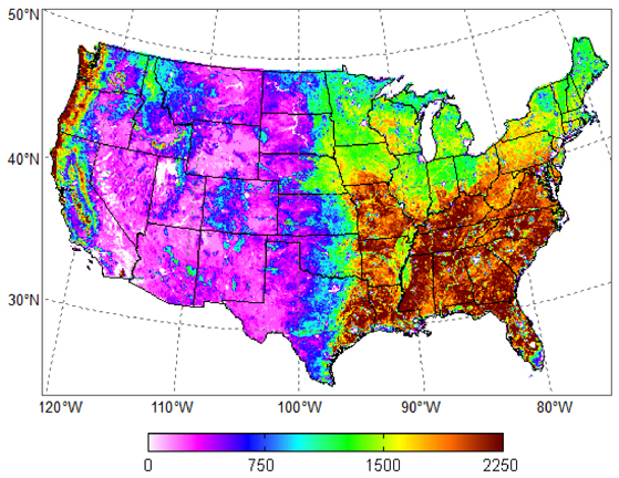
| Gross primary productivity (GPP) across the conterminous United States for 2006. GPP is the amount of carbon fixed by vegetation through photosynthesis and a key component of ecosystem carbon fluxes and the carbon balance between the biosphere and the atmosphere. The units are grams of carbon per square meter per year. These estimates were derived from eddy covariance flux measurements and MODIS data using a regression tree approach. The details of this method are described in a paper published in 2010 by Xiao et al in Remote Sensing of Environment. |
The atmosphere’s role in the carbon cycle is well measured and fairly well known, and as a result scientists have a fairly high degree of confidence in models that simulate climate change from an atmospheric perspective. However, there is less confidence in terrestrial numbers.
Of the terrestrial carbon budget Frolking says, “In the broad sense we know what’s going on but it’s the details we don’t understand. We don’t know deforestation that well, we don’t close the carbon budget well, we don’t know what CO2 fertilization effects are on vegetation productivity very well, and we don’t know the fate of high-latitude carbon with respect to permafrost.”
In a 2001 Science paper, Princeton University’s Stephen Pacala et al (George Hurtt and Berrien Moore were among the co-authors) estimated the magnitude of the carbon sink for the conterminous terrestrial ecosystem in the U.S. between 1980-89 to be 0.3-0.58 petagrams per year (a petagram equals about 2.2 trillion pounds). Notes Xiao, “What we’re trying to do is to better understand the relative and combined impacts of various factors such as warmer temperatures, increased precipitation, CO2 enrichment, extreme climate events, nitrogen deposition, ozone pollution, and disturbances on ecosystems and thus to reduce the uncertainties associated with these estimates.”
Unlike the atmosphere and the global ocean, which are both well-mixed fluids, the terrestrial biosphere doesn’t become homogenized. Thus, the variables that affect the carbon cycle in terrestrial systems can change a great deal from one spot to another.
For example, in a parcel of forest there is variation in soil minerals, roots, fungi, and decomposing plant litter and things often look different if you move to a spot just 50 feet away. And, says CSRC terrestrial ecologist Scott Ollinger, “There’s the imprint of disturbance and past land-use history, which also don’t get blended together as they would in air or water. And the result of all this creates a sampling problem. There’s a tremendous amount of complexity to account for and no one method offers a perfect solution.”
 |
|
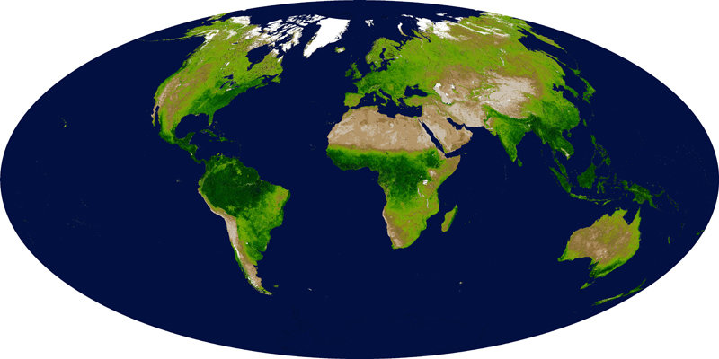
| By carefully measuring the wavelengths and intensity of visible and near-infrared light reflected by the land surface back up into space, the Moderate-resolution Imaging Spectroradiometer (MODIS) team can quantify the concentrations of green leaf vegetation around the world. The above MODIS Enhanced Vegetation Index (EVI) map shows the density of plant growth over the entire globe. Very low values of EVI (white and brown areas) correspond to barren areas of rock, sand, or snow. Moderate values (light greens) represent shrub and grassland, while high values indicate temperate and tropical rainforests (dark greens). The MODIS EVI gives scientists a new tool for monitoring major fluctuations in vegetation and understanding how they affect, and are affected by, regional climate trends. Image courtesy MODIS Land Group/Vegetation Indices, Alfredo Huete, Principal Investigator, and Kamel Didan, University of Arizona. |
Eddy flux towers are micrometeorological stations that measure the turbulence or “eddies” of air above treetops for minute amounts of CO2, water vapor, and energy between the biosphere and the atmosphere. The only means of scaling up the data to look at variability across a continent is via remote sensing (like the MODIS imagery, for example, which gives continuous coverage over space and time), and/or through modeling.
Xiao’s efforts will help broaden the terrestrial carbon cycle picture and, in time, he plans to push the data to the global scale. “By quantifying the amount of carbon sequestered or released by ecosystems over regions, continents, or the globe we can better understand the feedbacks between the terrestrial biosphere and the atmosphere. This knowledge is essential for facilitating climate policymaking and projecting future climate change,” he says.
This will dovetail to some extent with another current effort aimed at policymaking – work being done by George Hurtt, who specializes in ecological modeling. Hurtt is lead investigator for a project aimed at using satellite data to reduce uncertainties in forest ecosystem modeling and, ultimately, improve policies crafted to mitigate climate change. NASA’s Terrestrial Ecology Program funds the project.
Central to Hurtt's project is the Ecosystem Demography Model (ED) he co-developed. For the project, ED will be coupled with a socio-economic model in an effort to simulate strategies for mitigating climate change, including strategies that involve biofuels and changes to wood production rates and usage under altered climate conditions.
“By combining ED with the economic model we can now explore with greater accuracy and process detail the potential for afforestation or bioenergy crop production to help stabilize atmospheric CO2,” Hurtt says.
Adds Ollinger, “Enacting policy in a meaningful way means we need good numbers. If a state or country is going to claim a certain amount of carbon credits because it protected some forestland, we need to know what the carbon budget of that forestland really is. Presently, the numbers we have are murky at best.”
Eventually, these efforts could lead to collaboration between EOS researchers and social scientists – something Xiao and others are hoping to explore. Such collaboration would be a required part of any attempt to predict future changes in land use and land cover – an enormously important part of the terrestrial carbon cycle but one that is equally difficult to address. -DS
by David Sims, Science Writer, Institute for the Study of Earth, Oceans, and Space. Published in Winter 2010 issue of EOS .