The Age of Aquarius
An upcoming satellite mission involving OPAL scientists will provide the third “state variable” in global ocean observations and a key link to Earth’s climate
THE CYCLING of water and energy through the atmosphere and oceans is crucial to life on Earth. Yet the ties among the water cycle, ocean circulation, and climate are poorly understood.
Knowledge of the distribution of sea surface salinity, or SSS, over time is critical to resolving these relationships. But through history, surface salinity has been only sparsely measured at sea, limited mostly to summertime observations in shipping lanes.
Knowledge of the distribution of sea surface salinity, or SSS, over time is critical to resolving these relationships. But through history, surface salinity has been only sparsely measured at sea, limited mostly to summertime observations in shipping lanes.
However, the observational gap has been changing rapidly during the last decade, and when the international Aquarius satellite is launched next year, within just a few months it will collect as many surface ocean salinity measurements as have been gathered by ships and buoys since 1885.
In one year of circling the globe, Aquarius will fill in massive blank areas of the world’s oceans that have never had salinity measurements made and will provide scientists with a global view of salinity variability and a new perspective on the ocean and its links to climate.
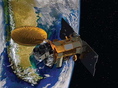
The satellite, which is being jointly developed by NASA and the Space Agency of Argentina, is known as the Aquarius/Satelite de Aplicaciones Cientificas-D (SAC-D) mission, and represents three decades of scientific and technical development needed to finally measure SSS accurately from above Earth's surface.
Aquarius data will allow scientists to better monitor variations in the water cycle, including land runoff into the ocean, sea ice freezing and melting, and evaporation and precipitation over the oceans. Global SSS data will lead to the refinement of global climate models that bridge ocean-atmosphere-land-ice systems, with the goal of predicting future climate conditions.
Moreover, the accuracy with which the satellite will measure salinity changes – to a level equivalent to a pinch-of-salt in half a gallon of seawater – will help answer outstanding scientific questions relative to the coupling between the ocean and the freshwater cycle.These include: why is the Atlantic Ocean the saltiest; how do changes in rainfall over the tropical oceans – and the resulting effects on salinity – influence the development of monsoons; how can salinity data be used to improve climate models, El Niño, and La Niña forecasts; what is the variability of oceans’ temperature and salinity-controlled circulation (thermohaline) – often depicted as a "Global Conveyor Belt,” and how might changes in this huge system lead to climate change in Europe and other areas?
The third state variable: seawater density and the motion of our ocean
Along with sea surface temperature and pressure, Aquarius’ observations of salinity will provide the third, key measurement for remotely sensing the global oceans because it will help scientists to measure seawater density for the first time.
Having global salinity measurements stands to revolutionize water cycle studies in the ocean because density is involved in a variety of key processes, such as driving ocean currents and regulating the vertical distribution of photo- and zooplankton. And small changes in density can drive big changes in the motion of ocean waters.
“So salinity has been the missing piece of the puzzle and this really opens up the game for water cycle science,” says UNH co-investigator Joe Salisbury, research assistant professor in the Ocean Process Analysis Laboratory. It will also complement ongoing studies within OPAL that are looking to understand how water and materials from the land influence continental shelf ecosystems. “We always want to know more about how organisms and carbon behave relative to salinity distributions,” Salisbury adds.
“It’s quite an undertaking and it will be a technical achievement just to infer information about sea surface salinity from these microwave measurements,” says research associate professor Doug Vandemark of OPAL and Aquarius science team member. Vandemark, trained as an electrical engineer and oceanographer, is an expert in microwave satellite remote sensing. Microwave energy is the only way yet devised to measure sea surface salinity from space. But there is plenty of “noise” in the air that blurs a sensor’s ability to make these readings.
Even small wave action can interfere with the ocean microwave signal being tracked by a satellite, as can, for that matter, radiation from the center of the Milky Way galaxy and Asian cell phone towers. A series of radar stations that provide surveillance from potential incursions or attacks from across North America's polar region are the biggest interference factors on the “L-band” microwave energy frequencies.
Thus, part of Vandemark’s job for the Aquarius mission will be developing “corrections” for all this interference so that the salinity readings are as clean and accurate as possible.
A river runs into it, in a big way
As scientists, Salisbury and Vandemark are most interested in the Aquarius salinity measurement as it applies to big rivers dumping freshwater into the salty sea. This land/ocean interaction is a lesser part of the whole water cycle – the atmosphere/ocean and ice/ocean components being much larger. But the vast loads of freshwater flowing into the ocean from our largest rivers, for example, the Amazon, Bhramaputra, or Mississippi, do indeed have equally vast implications for the surrounding coastal areas.
For example, the Bhramaputra’s water flows into the Indian Ocean’s Bay of Bengal, the largest bay in the world, and ends up controlling how the bay circulates. The freshwater doesn’t mix very well into the seawater but, rather, sits on top forming a “barrier layer” that traps heat. All of this sets up a huge water cycle feedback loop that helps to control the monsoon rains, which return more freshwater into the Bhramaputra watershed, and so on.
The Amazon is another river of interest to Salisbury and Vandemark for both SSS and ocean color studies. Satellite ocean color data allows scientists to monitor biogeochemical aspects of the coastal ocean as plumes of tea-colored, carbon-rich freshwater flow into the sea. Varying with the season, the mighty Amazon pours almost 60 million gallons of freshwater into the Atlantic Ocean every second and this massive influx dilutes the ocean's salinity for up to 1,000 miles offshore.
It was a satellite mission over the Amazon that provided Vandemark with one of the few eureka moments of his career and provided him and other project engineers with new confidence that the Aquarius mission will be successful.
NASA’s Earth Observing System (EOS) Aqua satellite, launched in 2002, has onboard the Advanced Microwave Scanning Radiometer (AMSR-E) sensor to observe atmospheric, land, oceanic, and cryospheric parameters. These include precipitation, sea surface temperatures, ice concentrations, snow water equivalent, surface wetness, wind speed, atmospheric cloud water, and water vapor. The sensor was not intended to measure sea surface salinity because the microwave frequency it uses is much less sensitive to salinity variations.
But Vandemark, working with a team of colleagues from the French Institute of Research for the Exploitation of the Sea, discovered that AMSR-E could in fact make the SSS measurement, albeit at a “noisier” level than what scientists are hoping to achieve with Aquarius and are also currently finding with the Soil Moisture and Salinity (SMOS) mission – a European Space Agency satellite launched in December 2009. SMOS features an L-band radiometer, like Aquarius, but the SMOS measurement focus is more on terrestrial soil moisture and finer spatial resolution measurements while the sole Aquarius focus is accurate ocean salinity observations.
Says Vandemark, “We collaborate closely with the project scientists and engineers for the SMOS mission and, between us, we came up with this idea of how to make salinity measurements from AMSR-E that will complement those made by SMOS and Aquarius. These measurements, which go back to 2002, are going to be able to tell us things about how the large rivers influence oceans. They provide a certain niche of microwave readings over warm, equatorial waters like the Amazon’s influx into the Atlantic, which is exactly our area of interest and expertise here at OPAL.”
He adds, “So we’re really in the right scientific mix with these satellite missions and are excited about working with ocean salinity for the next decade. We’re actually looking to create our own cottage industry here at UNH by blending ocean color data with the AMSR-E salinity product, and Aquarius and SMOS data.”
Knowledge of the distribution of sea surface salinity, or SSS, over time is critical to resolving these relationships. But through history, surface salinity has been only sparsely measured at sea, limited mostly to summertime observations in shipping lanes.
Knowledge of the distribution of sea surface salinity, or SSS, over time is critical to resolving these relationships. But through history, surface salinity has been only sparsely measured at sea, limited mostly to summertime observations in shipping lanes.
 | |
| Artist's conception of the Aquarius/SAC-D satellite in orbit over South America.Image courtesy of NASA. |
In one year of circling the globe, Aquarius will fill in massive blank areas of the world’s oceans that have never had salinity measurements made and will provide scientists with a global view of salinity variability and a new perspective on the ocean and its links to climate.
The satellite, which is being jointly developed by NASA and the Space Agency of Argentina, is known as the Aquarius/Satelite de Aplicaciones Cientificas-D (SAC-D) mission, and represents three decades of scientific and technical development needed to finally measure SSS accurately from above Earth's surface.
Aquarius data will allow scientists to better monitor variations in the water cycle, including land runoff into the ocean, sea ice freezing and melting, and evaporation and precipitation over the oceans. Global SSS data will lead to the refinement of global climate models that bridge ocean-atmosphere-land-ice systems, with the goal of predicting future climate conditions.
Moreover, the accuracy with which the satellite will measure salinity changes – to a level equivalent to a pinch-of-salt in half a gallon of seawater – will help answer outstanding scientific questions relative to the coupling between the ocean and the freshwater cycle.These include: why is the Atlantic Ocean the saltiest; how do changes in rainfall over the tropical oceans – and the resulting effects on salinity – influence the development of monsoons; how can salinity data be used to improve climate models, El Niño, and La Niña forecasts; what is the variability of oceans’ temperature and salinity-controlled circulation (thermohaline) – often depicted as a "Global Conveyor Belt,” and how might changes in this huge system lead to climate change in Europe and other areas?
The third state variable: seawater density and the motion of our ocean
Along with sea surface temperature and pressure, Aquarius’ observations of salinity will provide the third, key measurement for remotely sensing the global oceans because it will help scientists to measure seawater density for the first time.
Having global salinity measurements stands to revolutionize water cycle studies in the ocean because density is involved in a variety of key processes, such as driving ocean currents and regulating the vertical distribution of photo- and zooplankton. And small changes in density can drive big changes in the motion of ocean waters.
“So salinity has been the missing piece of the puzzle and this really opens up the game for water cycle science,” says UNH co-investigator Joe Salisbury, research assistant professor in the Ocean Process Analysis Laboratory. It will also complement ongoing studies within OPAL that are looking to understand how water and materials from the land influence continental shelf ecosystems. “We always want to know more about how organisms and carbon behave relative to salinity distributions,” Salisbury adds.
“It’s quite an undertaking and it will be a technical achievement just to infer information about sea surface salinity from these microwave measurements,” says research associate professor Doug Vandemark of OPAL and Aquarius science team member. Vandemark, trained as an electrical engineer and oceanographer, is an expert in microwave satellite remote sensing. Microwave energy is the only way yet devised to measure sea surface salinity from space. But there is plenty of “noise” in the air that blurs a sensor’s ability to make these readings.
Even small wave action can interfere with the ocean microwave signal being tracked by a satellite, as can, for that matter, radiation from the center of the Milky Way galaxy and Asian cell phone towers. A series of radar stations that provide surveillance from potential incursions or attacks from across North America's polar region are the biggest interference factors on the “L-band” microwave energy frequencies.
Thus, part of Vandemark’s job for the Aquarius mission will be developing “corrections” for all this interference so that the salinity readings are as clean and accurate as possible.
A river runs into it, in a big way
As scientists, Salisbury and Vandemark are most interested in the Aquarius salinity measurement as it applies to big rivers dumping freshwater into the salty sea. This land/ocean interaction is a lesser part of the whole water cycle – the atmosphere/ocean and ice/ocean components being much larger. But the vast loads of freshwater flowing into the ocean from our largest rivers, for example, the Amazon, Bhramaputra, or Mississippi, do indeed have equally vast implications for the surrounding coastal areas.
For example, the Bhramaputra’s water flows into the Indian Ocean’s Bay of Bengal, the largest bay in the world, and ends up controlling how the bay circulates. The freshwater doesn’t mix very well into the seawater but, rather, sits on top forming a “barrier layer” that traps heat. All of this sets up a huge water cycle feedback loop that helps to control the monsoon rains, which return more freshwater into the Bhramaputra watershed, and so on.
The Amazon is another river of interest to Salisbury and Vandemark for both SSS and ocean color studies. Satellite ocean color data allows scientists to monitor biogeochemical aspects of the coastal ocean as plumes of tea-colored, carbon-rich freshwater flow into the sea. Varying with the season, the mighty Amazon pours almost 60 million gallons of freshwater into the Atlantic Ocean every second and this massive influx dilutes the ocean's salinity for up to 1,000 miles offshore.
It was a satellite mission over the Amazon that provided Vandemark with one of the few eureka moments of his career and provided him and other project engineers with new confidence that the Aquarius mission will be successful.
NASA’s Earth Observing System (EOS) Aqua satellite, launched in 2002, has onboard the Advanced Microwave Scanning Radiometer (AMSR-E) sensor to observe atmospheric, land, oceanic, and cryospheric parameters. These include precipitation, sea surface temperatures, ice concentrations, snow water equivalent, surface wetness, wind speed, atmospheric cloud water, and water vapor. The sensor was not intended to measure sea surface salinity because the microwave frequency it uses is much less sensitive to salinity variations.
But Vandemark, working with a team of colleagues from the French Institute of Research for the Exploitation of the Sea, discovered that AMSR-E could in fact make the SSS measurement, albeit at a “noisier” level than what scientists are hoping to achieve with Aquarius and are also currently finding with the Soil Moisture and Salinity (SMOS) mission – a European Space Agency satellite launched in December 2009. SMOS features an L-band radiometer, like Aquarius, but the SMOS measurement focus is more on terrestrial soil moisture and finer spatial resolution measurements while the sole Aquarius focus is accurate ocean salinity observations.
Says Vandemark, “We collaborate closely with the project scientists and engineers for the SMOS mission and, between us, we came up with this idea of how to make salinity measurements from AMSR-E that will complement those made by SMOS and Aquarius. These measurements, which go back to 2002, are going to be able to tell us things about how the large rivers influence oceans. They provide a certain niche of microwave readings over warm, equatorial waters like the Amazon’s influx into the Atlantic, which is exactly our area of interest and expertise here at OPAL.”
He adds, “So we’re really in the right scientific mix with these satellite missions and are excited about working with ocean salinity for the next decade. We’re actually looking to create our own cottage industry here at UNH by blending ocean color data with the AMSR-E salinity product, and Aquarius and SMOS data.”
by David Sims, Science Writer, Institute for the Study of Earth, Oceans, and Space. Published in Winter 2010 issue of EOS .

