Spring 2013
Climate Change Research at EOS
BACK IN THE SPRING OF 2004, when the Center for Coastal Ocean Observing and Analysis (COOA) began monthly scientific cruises in the Gulf of Maine, the term "ocean acidification" had yet to enter the vernacular of climate change.
Just five years later, the Federal Ocean Acidification Research and Monitoring Act was passed and, in its wake, the National Oceanic and Atmospheric Administration established its Ocean Acidification Program in recognition that the problem of rising ocean acidity "is emerging as an urgent environmental and economic issue on our nation's east and west coasts and in many areas of the world."
 |
|
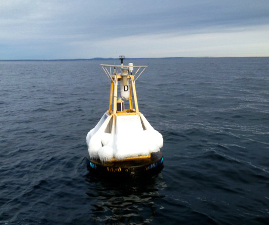
| UNH carbon dioxide sentinel buoy off Appledore Island after January 2013 Nor'easter. Photo by Shawn Shellito, UNH-EOS. |
Making measurements relevant to tracking ocean acidification—although not named as such—was already one part of why the COOA cruise "transects" were initiated: to better understand the complex dynamics of coastal ocean waters, most particularly the role they play in either storing or out-gassing atmospheric carbon dioxide.
"The biggest thing we were asking at the start was, 'Is the Gulf of Maine a sink or source of carbon dioxide?' At the time, no one on the East Coast knew very well what the coastal ocean was doing in this regard," says Doug Vandemark, research associate professor and director of the Ocean Process Analysis Laboratory (OPAL).
He adds, "And it was important to find out because, among other things, if our region's ocean is a big sink, is it large enough that we need to include it in the total ocean budget for CO2 uptake?"
What has been generally known is that continental shelf systems like the Gulf of Maine are highly productive biologically because they receive large nutrient input from both the land and adjacent ocean waters.
And because the annually recurring process of biological growth uses carbon dioxide, it has been suggested that these systems serve as pumps that draw the gas out of the atmosphere and sink it into the deep blue sea—an important role in the global ocean carbon cycle despite the fact that coastal systems represent just seven percent of the global ocean surface.
After gathering enough data year after year to provide a time series—measurements of sufficient length, consistency, and continuity to determine climate variability and change—COOA researchers have now shown that the Gulf of Maine is neither a clear sink nor source of carbon dioxide but, rather, a sort of recycling center for the greenhouse gas.
Says Vandemark, "Although like most coastal systems the air-sea CO2 exchange is highly variable in both time and space, we've concluded that the Gulf has both a time of year when CO2 is sinking and a time when it's ejecting the gas. And in most years, the exchange turns out to be in net balance."
A marginal sea
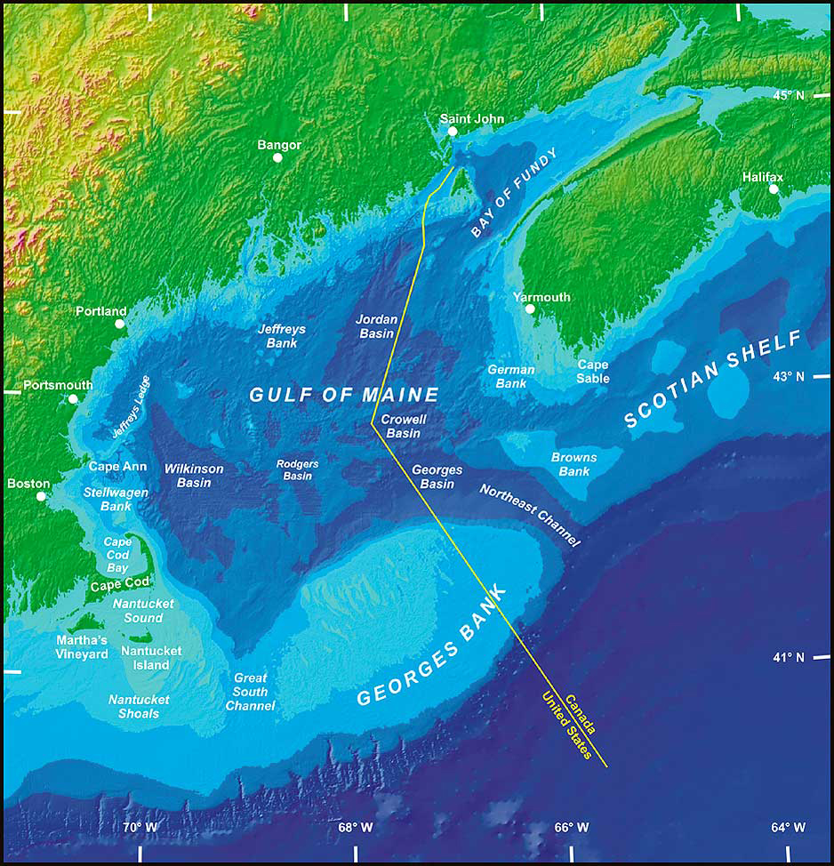
One reason for this net balance is that the 69,120-square-mile body of water is a semi-enclosed basin or what's known as a marginal sea because several effective gateways, including channels around big George's Bank, limit what is exported permanently out of the system.
"While we do observe a lot of biological production, we don't have the pumping/export mechanism to flush the organic carbon out before it comes back up and is recycled," Vandemark says. "That is the most fundamental observational result from our time series data so far."
 |
|
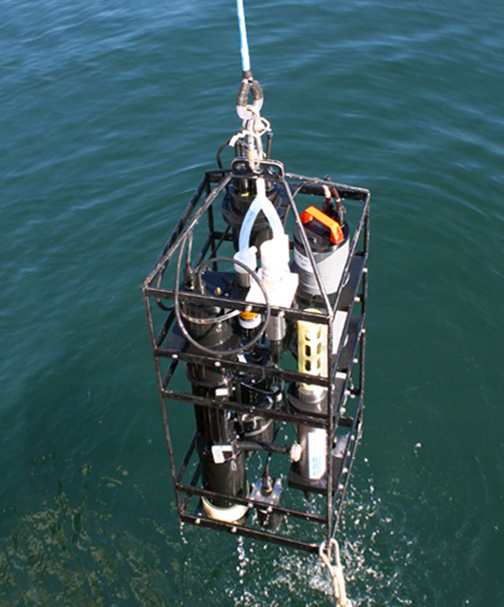
| Instrument package used during the COOA cruise "transects" to better understand the complex dynamics of coastal ocean waters. Photo by Shawn Shellito, UNH-EOS. |
Vandemark adds that a next step in the scientific inquiry is seeking to understand how fragile this balance is over time. "This has required expanding our observations and attempting to develop models for how that balance is maintained by a mix of key processes, including seasonal temperature, wind, ocean mixing, and biological changes."
Since 2010, and with recent additional support from NOAA's Ocean Acidification office, the scientists' data collection has focused on hourly measurements at the UNH carbon dioxide buoy located northeast of Appledore Island. The buoy is now routinely deployed for nine to ten months per year by a UNH team headed by OPAL research scientist Shawn Shellito and research professor Jim Irish of the UNH Ocean Engineering program.
A recent addition to the buoy is the region's first autonomous ocean acidity (pH) measurement sensor. The complement of daily chemical, biological and physical oceanographic data recorded by this buoy will serve as the foundation for understanding the Gulf of Maine's fragile carbon balance.
Without the long-term time series shipboard data, which have been supplemented by the UNH buoy-based measurements, the scientists would have something more akin to the old lead-line soundings used to measure the ocean bottom—a very fuzzy understanding of the bigger picture.
But as carbon dioxide levels continue to rise in both the atmosphere and the ocean, even longer-term measurements, on the scale of decades, will be required to help develop the models needed to accurately predict what the future may hold.
Model meets data
"The cruise and buoy data have shown us that there is profound variability in the water temperature, salinity, and probably biology on a year-to-year basis," says OPAL oceanographer Joe Salisbury. "We can tell a lot about what's causing the variability in CO2 by looking at how temperature and salinity change, but we aren't able to see clear trends over the nine years and we need to continue to make measurements on the scale of decades for a clearer picture to emerge."
Among other physical ingredients, the temperature, salinity, and biology of coastal waters cause carbon dioxide and acidity levels to vary on wide spatial and temporal scales.
 |
|
| The Gulf of Maine is a semi-enclosed or "marginal sea" because several effective gateways, including channels around George's Bank, limit what is exported permanently out of the system. Digital bathymetry map by Ed Roworth and Rich Signell of the U.S. Geological Survey, courtesy of the Regional Association for Research on the Gulf of Maine. |
For example, Salisbury, who specializes in studying the effects of freshwater input from the region's many large rivers on the Gulf of Maine, notes that cruise and buoy data record the impact of storms and subsequent plumes of tea-colored freshwater that pour into coastal waters. Such sediment- and nutrient-loaded water can have profound impacts, such as darkening the coastal in-water light field, resulting in dramatic impacts on biological production, or lack thereof.
But teasing out what it all means with respect to carbon dioxide and levels of acidity is extremely difficult without a robust, coupled physical-biological ocean model that is driven by real data. No such model currently exists and Salisbury is in the process of trying to develop an "observationally oriented" model that doesn't include all the vagaries of coastal ocean processes.
Notes Vandemark, "One thing we've learned well is that the coastal ocean is very messy, but Joe is modeling the biophyiscal coupling in a fairly simple way that provides valuable first answers to guide future measurement and modeling work."
A decade of data for the decade ahead
Looking at their ocean carbon dioxide time series data, Salisbury points out, "We're trying to simplify the analysis to basically one dimension—looking at time series data in a place that's a highly three-dimensional system. There's input to the waters from below, from the side, from the north, sometimes from the south, from river waters of the Penobscott and Kennebec, small local rivers with different signature, etcetera, and we're using very simple models to try and figure that all out. But it's an extremely complex story."
To address this complexity, the two scientists are also working with modelers at Rutgers University to help improve that group's Regional Ocean Modeling System, which has been used to simulate the air-sea flux of carbon dioxide (the exchange of the gas between the surface of the sea and the overriding atmosphere) on the northeast continental shelf without the inclusion of real-world measurements, which remain sparse.
"In order to model whether the Gulf of Maine is going to continue to stay in that balance or become a sink or source," Vandemark says, "we need to know what our predictive capabilities are and how good they are. That requires more time-resolved, long-term measurements so we can look at actual data one year versus ten years later to see if the models get it right. That's one thing our data will go towards for the next decade."
In addition to the joint work with Rutgers and Salisbury's modeling efforts, continued and expanded measurements will be made in the Gulf of Maine to track shifting levels of carbon dioxide and ocean acidity in both time and space. The group has deployed instruments across the Gulf of Maine, including sites in the Northeast Channel in the middle of the Gulf, an estuary in Casco Bay, and within the Stellwagen Marine Sanctuary east of Boston.
The need for expanded measurements related to ocean acidification was hammered home by a study published this past January that demonstrates how vulnerable the Gulf of Maine is to acidification. The study, whose lead author is former UNH graduate student Aleck Wang—now a chemical oceanographer at the Woods Hole Oceanographic Institution, was based on a summer 2007 investigation aboard NOAA's Research Vessel Ronald H. Brown in which Salisbury, along with former graduate student Amanda Plagge, participated.
Says Salisbury, "We've known for some time from our observations that the Gulf of Maine's coastal and bottom waters are poorly buffered against changes in acidity. However, this study puts our system in the context of all coastal waters from Maine to Texas, and suggests that we'll be the most vulnerable in the coming years."