Spring 2012
THE PRACTICE OF "citizen science," in which John and Jane Doe and their kids gather valid scientific data, has been around for a couple decades. But with the profusion of high-tech gadgets that allow instant information gathering and sharing now upon us, citizen science is entering a new realm of relevance and veracity.
This is particularly true with respect to documenting aspects of climate change because the scope and scale of our changing climate lends itself, requires even, a vast monitoring effort right down to the local level. In today's parlance, citizen science taps into the power of "crowd sourcing" in an effort to document and monitor "place-based" environmental change.
 |
|
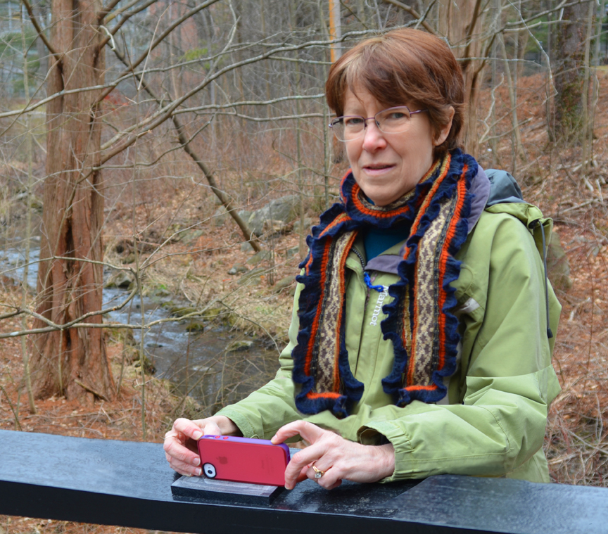
| Annette Schloss of the Earth Systems Research Center. Photo by Kristi Donahue, UNH-EOS. |
The Cyber-Infrastructure Digital Education and Research (CIDER) project builds on a long legacy of ESRC research in global biogeochemical cycles and related efforts to extend the research for geospatial teaching and community engagement. The newly established UNH Center for Excellence in Geosciences Education (CEGE) is collaborating on the project to help get the tools CIDER develops into the hands of teachers and students.
"What CIDER is trying to do is build comprehensive cyber infrastructure primarily for middle school students and citizen scientists," says Schloss. "We want the students in particular to start thinking about their cell phones or other handheld mobile devices as more than just entertainment or toys. These are, in fact, tools that can be used for science investigations, for research."
Schloss notes that there is a "big push" to increase cyber learning at the national level, and that the National Science Foundation (NSF) in particular is paving the way. CIDER is the result of a two-year, $250,000 grant from NSF to demonstrate the project's potential. Also active in the project are Erik Froburg of the Leitzel Center and CEGE, Michael Palace of ESRC, Michael Routhier of the GIS Lab, Bill Armstrong of Research Computing and Instrumentation, and educational collaborator Jeffrey Beaudry from the University of Southern Maine.
Says Schloss, "One nice thing about CIDER is that it brings together a lot of ongoing projects here at ESRC – science research, data management, education and outreach, and existing cyber infrastructure like EOS-WEBSTER – to build a more comprehensive and readily accessible resource for educators. It's very inclusive."
A central part of CIDER will be the use and further development of a simple environmental monitoring technique called Picture Post that Schloss helped create with educator John Pickle of Concord (Mass.) Academy.
 |
|
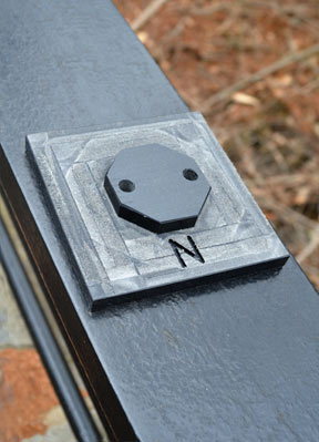
| Closeup of a Picture Post's octagonal platform for mounting a cell phone camera or digital camera. The lower portion points North. Photo by Kristi Donahue, UNH-EOS. |
It's simple enough for anyone to do and, indeed, as Picture Post's website points out, the challenge of performing accurate scientific monitoring is to return on a regular basis, ideally once a week or once every two weeks, to record changes in the environmental scene.
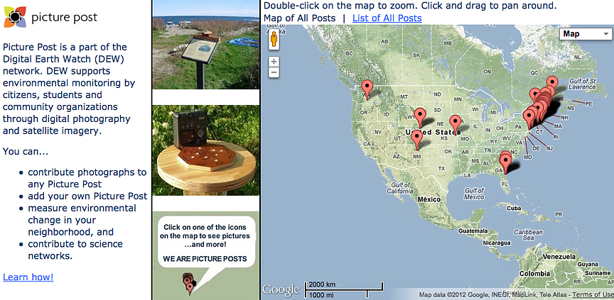
Picture Post, which is one of the data systems housed within EOS that will be an integral part of the CIDER web portal, is a part of NASA's Digital Earth Watch network. The network supports environmental monitoring by citizens, students and community organizations through digital photography and satellite imagery.
At the Picture Post website, along with the panoramic shots photographers upload directly to the site, is satellite imagery of the same location where the photos were taken. At the moment, these images from the Moderate Resolution Imaging Spectroradiometer (MODIS) instrument aboard NASA's Aqua and Terra satellites provide little more than atmospheric context for the picture takers. But part of the project's work is to create tools that will allow scientists and citizen scientists to use the Picture Post photographs to validate or "ground truth" the satellite imagery.
ESRC research assistant professor Mary Martin and former UNH graduate student Haley Wicklein (now a research assistant in the ESRC Terrestrial Ecosystem Analysis Laboratory) have begun exploring this possibility by correlating the greenness index of trees in Picture Post photographs with MODIS albedo (reflectance) measurements. The greenness index is the ratio between the total vegetated area and the total geographical area covered. Low greenness index values indicate poor green cover that could be the result of climatic changes. Events that can cause low values include moisture shortages, extreme temperatures, and biotic interference. The correlation between the Picture Post photograph and the MODIS image indicates how accurate the satellite's readings are.
 |
|
| http://picturepost.unh.edu/ |
"Another thing you can do with Picture Post is monitoring phenology, which has become a huge topic of research interest," Schloss says. Phenology is the study of periodic plant and animal life cycle events and how these are influenced by seasonal and interannual variations in climate.
The National Ecological Observatory Network (NEON) is monitoring phenology via an effort called Project BudBurst and Schloss notes CIDER and Picture Post plan to plug into this large-scale citizen science effort that monitors the timing of leafing, flowering, and fruiting of plants – plant phenophases.
Like Picture Post's standardized approach to documenting specific environments, Project BudBurst data are being collected in a consistent manner across the country so that scientists can use the data to learn more about the responsiveness of individual plant species to changes in climate locally, regionally, and nationally.
Notes Schloss, "With climate change, you can't really talk about detecting a signal until you have at least a 30-year record, so with projects like Picture Post and Project BudBurst you're not only adding a detailed time record but also adding to the richness of the data set. In other words, a satellite image, be it a 30 meter or 250 meter pixel, is integrated over a very large area so you're not going to detect any local differences. And obviously climate change affects me locally as much as it affects the big picture."
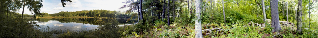 |
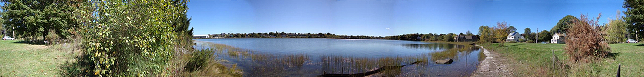
| A seamless ("stitched) panoramic view as taken by a camera mounted on a Picture Post. Photo courtesy of Annette Schloss, UNH-EOS. |
A "transformative" direction forward
Erik Froburg is the education and outreach specialist with the Leitzel Center and assistant director of the CEGE. For CIDER, Froburg will act as the "bridge" between the scientists and educators as the project seeks the best means of incorporating cyber-infrastructure and mobile technologies into geosciences education.
"I think this is an opportunity to do something truly transformative because you're using technology differently," Froburg says. "And from the student's perspective, I think you already have a head start if you're asking them to do science with their cell phone, for example, because they're already more engaged. They're going to use it in social ways anyway, so why not take advantage of other potential uses to engage them as well."
This meeting-students-where-they-live approach has the additional advantage of providing nearly instantaneous access to results – something kids have come to expect. For example, a student could be at a field site taking pictures and making measurements of tree size and height, upload the pictures that are all geospatially tagged via a cell phone's GPS, and within minutes be able to look at the data in some larger scientific context such as what that same site looked like several years previous.
"In my experience," says Froburg, "one of the big hang-ups between trying to make the connection between classroom science and real scientific research is that there are so many things working to disconnect them, if you will. And if we're able to better connect data to a student's life, increase the timeliness of that data by allowing them to gather it and immediately have access to it in a broader context, I think it makes it a little more tangible."
Improving the two-way flow of information from the field, that is, increasing the ability to send freshly gathered data and then have real-time access to it in some larger context, is something Michael Routhier and undergraduate technology students in the GIS Lab will be working on in building the cyber-infrastructure.
Both Schloss and Froburg note that a potential downside to citizen science of the past has been suspect data due to lack of training and non-standard data collection techniques and equipment. But with an increasing reliance on everyday technology to get the job done, this downside is increasingly going away.
"The cyber-enabled approach is helping to solve some of the accuracy issues," says Froburg. "If you're using Picture Post, for example, the pictures students or citizen scientists take will be as good as anyone's, the technology is what it is, errors are less likely to be introduced, and there is much more likelihood of always getting quality data."
 |
| Photo courtesy of Annette Schloss, UNH-EOS. |