Fall 2012
IF AND WHEN, years hence, the Geostationary Coastal and Air Pollution Events satellite gets lofted into orbit to measure aspects of Earth's atmosphere and oceans, few people will recollect the time when the spacecraft was a mere twinkle in scientists' eyes.
But among those who will are oceanographer Joe Salisbury of the Ocean Process Analysis Laboratory and atmospheric scientist Carolyn Jordan of the Earth Systems Research Center. Both are part of a large scientific working group charged with taking the raw mission concept and putting meat on the bones.
 |
|
| http://geo-cape.larc.nasa.gov |
Scientists from around the country are currently dedicating long hours teleconferencing and brainstorming for little or no monetary compensation to come up with what's called a Science Traceability Matrix that will define the mission.
Says Jordan, fresh off a two-hour telecon, "The matrix is a one-page synopsis of the science questions the mission needs to answer and the instrument/mission requirements needed to do so, and it's the job of the working group to actually define all that."
Indeed, the mission, known as GEO-CAPE for short, was hatched from a very broad and general scientific notion—in this case the need to get detailed, continuous measurements of air quality and ocean color from a spacecraft "parked" above Earth in a geostationary orbit.
"In order to answer the science questions that were broadly disseminated in the National Research Council's Decadal Survey," notes Salisbury, co-leader of the mission's ocean science working group, "they needed to look down at a water mass or plume or the atmosphere repeatedly over the course of a day. This provides information about the temporal dynamics to a higher degree than you'd get with a satellite in a polar orbit around the globe."
Among other things, Salisbury specializes in coastal ocean color work, which reveals the presence of varying amounts of phytoplankton, sediments, and dissolved organic chemicals. Ocean color data provide information on the ocean's essential functions and resources, and can be used to assess long-term climate changes, evaluate support of fisheries production, and detect harmful algal blooms, etc.
As Salisbury notes, the 2007 NRC report, "Earth Science and Applications from Space: National Imperatives for the Next Decade and Beyond," provided a basic blueprint for how best to attain critical scientific information about the Earth system from space. This included a three-tiered group of recommended satellites, with Tier 1 missions slated for quickest development and launch. GEO-CAPE is a Tier II mission originally recommended for launch in the 2013-2016 time frame.
"The decadal survey basically states that we should be able to make certain measurements and understand certain processes as they relate to some burning scientific issue such as climate change, for example," Salsibury says. "Within that context, it's up to the initial science working groups to define what we specifically need to measure, how we'll measure it, and where we want the sensor to be—what slice of space above Earth do we want to reside in."
Currently, there are no U.S. geostationary satellites dedicated to ocean color work, and continuous monitoring of one location over coastal oceans in particular is needed because of the highly dynamic and fast-moving nature of these waters. If, for example, a polar-orbiting satellite snaps a single image of an area at noon and then does the same thing 24 hours later, what was pictured the day before could be 30 kilometers away due to the currents.
 |
|
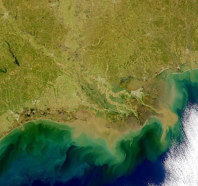
| Louisiana coast and the dynamic coastal region showing the suspended sediments, organic matter and phytoplankton. Image courtesy of NASA Sea-viewing Wide Field-of-view Sensor (SeaWiFS) Project. |
"So if you want to watch how a water parcel evolves, and there are really good reasons to do that, then a geostationary sensor is the only practical way to go," Salisbury says.
Imagine how uninformative a weather forecast based on just one picture per day of a certain region on Earth would be; NOAA's Geostationary Satellite system makes accurate weather tracking and forecasting possible via a time series of images from the GOES-East and GOES-West satellites parked in the upper atmosphere.
Some of the "really good reasons" why Salisbury's particular work requires a geostationary satellite are the measurement of three critical variables in ocean color, which is literally the light or "water leaving radiance" as detected by the satellite sensor. Ocean color is generated by various chemicals and critters and Salisbury's quarry includes chlorophyll, phytoplankton biomass, and sediments, among other things.
Phytoplankton biomass is a core part of the global carbon cycle and important to understand because its variability helps drive the "biological pump" that takes atmospheric carbon dioxide and sinks it to the deep ocean where it doesn't interact with the ocean/air interface. This huge carbon "sink" helps slow the pace of global warming.
In coastal ocean waters, there's often a great deal of tea-colored material pouring in from rivers and estuarine systems. Ocean color satellite readings of this sediment-laden water can be used to discern different material properties and physical processes that are important to understand as part of the whole complex ocean-air system.
Letting the air out
So why a satellite mission dedicated to investigating the seemingly distinct questions of air quality and ocean color?
The short answer, says Jordan, is that both the air quality and ocean color scientific communities wanted a geosynchronous satellite to achieve their respective goals. Ironically, one of the biggest challenges for the ocean color community in making these measurements from space is to "remove" the atmosphere between the satellite sensor and the ocean surface.
Explains Jordan, who specializes in atmospheric aerosol and trace gas analysis, "Between the signal of water leaving radiance at the ocean's surface and what the satellite sees at the top of atmosphere is a lot of interference from aerosols, ozone, nitrogen dioxide, and water vapor. To get a clear, accurate ocean color reading you have to correct the signal by 'removing' the atmosphere, which is 90 percent or more of the signal that's being picked up."
 |
|
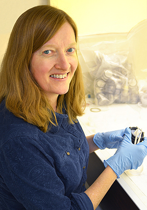
| Carolyn Jordan Photo by Kristi Donahue, UNH-EOS |
Thus, the joint atmosphere/ocean geostationary mission provides the opportunity to get high-quality 90/10 percent measurements at the same time, and then correct the signal for ocean color by subtracting the atmosphere.
Simple enough, but it turns out the spatial, temporal, and spectral requirements for the atmospheric science goals are different from those of the oceanic science goals. Back to the drawing board.
"There has been some tension between the two camps," Jordan says adding, "the instrument requirements are different enough that being joined at the hip makes it a more expensive mission and, ultimately, everyone worries that could mean we'll run out of money and never fly."
One workaround to this problem the scientists are now pursuing is, instead of the one, dedicated satellite as originally envisioned, the mission could get off the ground via a "hosted payload" with atmosphere and ocean color instruments each hitching a ride on separate commercial satellites.
Notes Jordan, "They would still both be in a geostationary orbit, and both still look at what they need to, respectively, but hopefully this would reduce the cost the mission. And, because this approach is now on the drawing board, the tension has mostly gone away."
Biggest science bang for nebulous bucks
There is always some inherent tension in the working group process, since the mandate is to come up with the best science for a mission within the context of a rather vague budgetary framework.
"We are not allowed, at this point in the process, to get very much budgetary guidance," says Salisbury. "For example, we can't go directly to a vendor and get a cost estimate for a multispectral instrument that scans the coastal region at certain wavelengths. So in that respect, we're operating at a disadvantage."
This is all part of the demanding spadework required of these groups, who largely volunteer their time and talent to help chart the nation's future space-based science capabilities.
Says Jordan, "Our mandate is to think about the best possible science, but since everything isn't possible, there will always be tradeoffs. And it can be hard to make those tradeoffs when we don't know what the associated costs are."
Salisbury notes that the working group may get a bit more budgetary guidance in fiscal year 2013 but, regardless, the process as designed does result in the all-important Science Traceability Matrix that gives tangible definition to the science particulars and can serve as the playbook for making the required tradeoffs. For example, agreed-upon options juxtaposed with the actual, physical limitations of the spacecraft will drive clear choices between, say, having better spatial or temporal or spectral resolution for the instrument chosen to do the job. Salisbury calls this the "trade-space matrix."
"So, if your interest is in identifying phytoplankton groups, and being able to distinguish the little critters from the big ones, you'll need really high spatial and spectral resolution, which will require a certain type and size of instrument. Someone else's interest/goal will demand yet another type of instrument. Each time you choose one option you have to sacrifice the other—this is 'trade space' in three dimensions, with the fourth being cost."
Salisbury and Jordan are just entering the third year of what could be a four-year effort for the science working group. Once their work is done, the group is disbanded and a mission science team is formed via a call for proposals. Then, design studies are initiated and the science and associated costs are finally pinned down. At which point the mission will be that much closer to go, no-go status.
It's true, the two scientists note, in the end their efforts could seemingly be all for naught should the satellite not get off the ground. But, says Salisbury, "The mission concept would be picked it up again in a decade. It was a mission recommended by the last decadal survey, people have been talking about it for years, and its finally gotten to the point where we're really trying to get it into the queue."
Of their front-end work Jordan says, "You move the ball forward, nudge it further down the path, and hopefully we'll be part of the science when the satellite finally goes up and starts making those measurements."
At the moment, the earliest possible launch date for the mission occurs sometime after 2020.
For more on the mission, visit the newly available GEO-CAPE website at http://geo-cape.larc.nasa.gov.