Fall 2013
Ocean Science
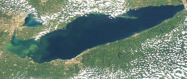
WHEN A LAKE of nearly 10,000 square miles develops problems, they tend to show up in a big way—like a 600-square-mile blob of toxic algae that closes beaches, fowls water treatment plants, and costs millions to combat "on the ground."
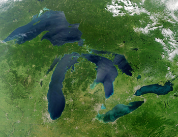
In an effort to address the problem from a higher level, Ocean Process Analysis Laboratory optical remote sensing specialist Tim Moore and colleagues spent a week on Lake Erie this past summer studying Microcystis—a poisonous alga that proliferates in freshwater lakes, particularly in western Lake Erie and Saginaw Bay in Lake Huron. With funding from the National Institutes of Health and the National Science Foundation, the study is aimed at developing algorithms for the detection, mitigation, and prediction of Microcystis via satellite.
The $600,000, three-year project is a collaboration between Moore at UNH, Colleen Mouw at Michigan Tech University, and Mike Twardowski and Jim Sullivan from Wetlabs—a private company in Rhode Island with expertise in in-water optics and instrumentation. The group is also working closely with NOAA's Great Lakes Environmental Research Laboratory in Ann Arbor, Michigan. Moore's particular expertise is ocean color remote sensing, which uses satellite data to detect optically active constituents such as phytoplankton and sediments in the oceans. According to Moore, applying his skills to inland waters presents a welcome change and new scientific challenges.
 |
|
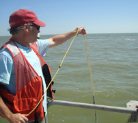
| Tim Moore. Photo by Kristi Donahue, UNH-EOS. |
|
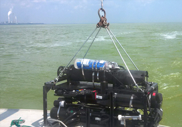
In August, the team cruised around the Lake Erie bloom and deployed a host of state-of-the-art, in-water instruments to gather environmental data. In tandem with simultaneous satellite measurements, these data will be used to develop the remote sensing algorithms—mathematical procedures or formulas used for solving a particular problem. In this case, the problem is being able to "see" the level of toxicity in the overall phytoplankton signal picked up by a satellite.
"The bloom patch we were in was just massive," says Moore, "and I'd never seen anything like this pea-soup green color. It has a very unique optical effect, which could aid in our being able to develop specific algorithms for Microcystis."
Microcystis, a cyanobacteria or blue-green algae, is the leading genus of these toxic blooms. It's specific toxin, microcystin, is a hepatotoxin, and damages the liver. Animals can die from drinking it and the risks to humans come from prolonged contact with skin causing rashes, lesions and blisters, and from swallowing the water, in severe cases causing seizures, liver failure, and respiratory arrest. The toxins produced by the algae can also contribute to oxygen-deprived dead zones where fish can't survive.
"It's a very serious environmental and social problem," notes Moore, who is the principal investigator of the project. "Our team specializes in water optics. NIH and NSF wanted to bring in this expertise because what we're doing in the Great Lakes is unique in terms of what's been done in the past."
Ringed by Detroit, Toledo, and Cleveland, Lake Erie's heavily industrialized coastline is dotted with nuclear and coal power plants. But the yearly, deadly algal blooms are fueled by the tremendous volumes of nutrient-rich agricultural runoff delivered by the Maumee River that flows through and drains vast farmlands in northwestern Ohio and northeastern Indiana.
Combating the toxins is challenging for operators of water treatment plants because there are no standards on how to handle the problem or federal guidelines on safe levels for drinking water.
From better to worse
Beginning in the mid-1970s, policies were implemented to reduce the nutrient loading, phosphate in particular, and were successful in reducing the toxic blooms. But in 1988, invasive zebra mussels were accidentally introduced to the Great Lakes via ship ballast. This has dramatically altered lake ecosystems and reopened a niche for the toxic algae to proliferate again, especially in warm summer temperatures.
 |
|
| Tim Moore lowers small optical instruments into the toxic algal bloom to gauge water turbidity Photo by Jim Sullivan, Wetlabs. |
|
In August, with the toxic algae in full bloom, Moore and colleagues took a host of continuous, in-water optical measurements with multiple instruments. “Our instrumentation should give us amazing optical data about the characteristics of the bloom,” Moore says.
And the team had the good fortune of experiencing a week of clear, cloud-free days and were thus able to get likewise clear remotely sensed imagery via the MODIS (Moderate Resolution Imaging Spectroradiometer) instrument aboard NASA's Earth-orbiting Terra and Aqua satellites.
Notes Moore, "We really lucked out, everything we measured with these in-water instruments will tie into the satellite remote sensing. We'll have a lot of good image sets matched with our in-water sets."
The general objective of the project is to derive a quantitative algorithm to detect these harmful blooms via satellite "and to develop some sort of proxy for toxin levels, which may be hard to do," Moore admits. "But in the process of getting to that point, the amount of optical data we've collected and the improvement to existing algorithms we'll bring to the table is going to be extremely useful."
While there are a handful of groups that go out on a weekly basis and measure levels of the toxins, these are measurements at discreet points and don't have the synoptic view of satellites. "And that's where we come in," says Moore, "we can improve these satellite images and get them closer to what people need, which are maps of microcystin toxin concentrations."
However, there are plenty of hurdles to overcome, from figuring out how to distinguish the phytoplankton biomass from the actual toxin levels, to environmental variables such as nutrient levels that affect toxin levels, to satellites capable of gathering the optical information needed to "see" the toxins.
MODIS doesn't have this capability, which was available on a European satellite no longer active. Moore notes that there is an imager on the International Space Station called HICO (short for Hyperspectral Imager for the Coastal Ocean) that has very high spectral and spatial resolution, so is ideal for this problem.
"We're looking at that data now, but unlike a dedicated, Earth-orbiting satellite it's sporadic."
Fresh territory
Moore has found it refreshing to move inland and use his expertise in ocean remote sensing on the waters of the nation's "Third Coast"—as the Great Lakes are sometimes called.
And, surprisingly perhaps, applying similar remote sensing techniques to the freshwater bodies is less common and more challenging in some senses compared to reading the oceans.
Says Moore, "There's a gap in the expertise for ocean color studies and lakes for a number of reasons. One is that lakes present a more complicated area to do optical algorithm development. There's a lot more material in the water that can affect water properties and complicate things. In the open ocean it's just phytoplankton. Coastal ocean waters can be more like lakes where you get suspended sediments and very high algal blooms, river runoff, and colored dissolved organic matter, all of which impacts the satellite signal."
And compared to the deep blue sea, lakes, even great lakes, present small targets by comparison and have lots of associated affects that mess up the signal—not the least of which is the "noise" introduced into the satellite signal by means of the huge volume of atmosphere that signal must contend with.
One of the biggest challenges for the ocean color community in making these measurements from space is to "remove" the atmosphere between the satellite sensor and the ocean surface—a technique known as "atmospheric correction."
That is, between the signal at the ocean's surface and what the satellite sees at the top of atmosphere there's a lot of interference from aerosols, ozone, nitrogen dioxide, and water vapor. To get a clear, accurate ocean color reading scientists have to correct the signal by eliminating that atmospheric noise, which is 90 percent or more of the signal that's being picked up.
“And the atmospheric correction is much more complicated for lakes because they have land adjacency effects, bottom affects,” Moore says. “They’re shallow compared to the open ocean and so you tend to see bottom reflection, and the aerosols aren’t well characterized over the land compared to the ocean. So it’s just a lot more complicated doing satellite work with lakes.”
Moore adds that these might not be uncharted waters from a scientific perspective, but by virtue of the instruments his teams brings to the problem “there is a lot of new territory to explore.”


