Fall 2014
Earth Systems Science
The hemlock woolly adelgid is the single greatest threat to hemlock health and sustainability in the East. The potential ecological impacts are comparable to that of Dutch elm disease and chestnut blight. —USDA Forest Service
It would seem like the very definition of looking for the proverbial needle in the haystack: using satellites to hone in on a 1/16-of-an-inch—about the size of the period at the end of this sentence—aphid-like insect under the forest canopy before visible signs of its destruction appear.
 |
|
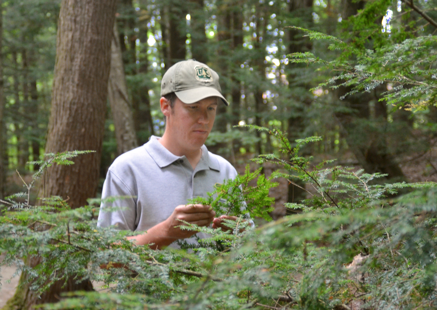
| Justin Williams inspects a hemlock branch. Photo by Kristi Donahue, UNH/EOS. |
But that’s precisely what master’s student Justin Williams set out to do as he began his thesis work three years ago, and just what he accomplished working with the US Forest Service under the federal Pathways Program.
"Under the Pathways Program, I was employed full-time and paired with a mentor from the Forest Service,” Williams says. “By working for the Forest Service I was able to use their resources, such as vehicles and scientific instruments, for my research while a graduate student at UNH.”
Although there have been efforts to use satellite imagery to map the damage or defoliation caused by the hemlock woolly adelgid—an invasive Asian insect that first appeared on the East Coast of the U.S. in the early 1950s—Williams’ work is unique in that it set out to map the distribution of the pest before major defoliation occurs and do so at a larger scale than previous efforts, almost 9,000 square kilometers using Landsat imagery compared to less than 1,500 square kilometers via other methods.
As of 2011, eighteen states from Maine to Georgia had infestations of hemlock woolly adelgid. The pest can kill a hemlock in just a few years, sucking it dry of the nutrients and starch reserves it needs to survive.
“Justin's work is quite significant,” notes Barry Rock of the Earth Systems Research Center and Williams’ advisor. “He has documented the ability to remotely detect hemlock woolly adelgid infestation using remote sensing methods and, most importantly, also showed there is an initial increase in needle chlorophyll concentrations before the trees eventually succumb to the disease, which appears to be the initial response in the trees’ attempt to ‘fight off’ the infection.”
This increase in needle chlorophyll concentration—indicated by how certain wavelengths of light are reflected back to the sensor—turned out to be the key finding in Williams’ work. And it was what made it possible to find the needle in the haystack.
“We knew the hemlock woolly adelgid was affecting the reflectance properties of individual hemlock needles based on some lab-based measurements that we made,” Williams says, “but we weren’t sure we would be able to pull those differences out with the satellite imagery where you’re dealing with mixed land cover pixels and confusion between coniferous species. So it was a very pleasant surprise.”
Boots on the ground
Before the surprise finding, Williams and colleagues used modeling and groundwork to identify where they would find suitable hemlock habitat in their study area, which ranged from a bit north of Concord and west to Mount Kearsarge in New Hampshire and, in Maine, north to Biddeford.
 |
|
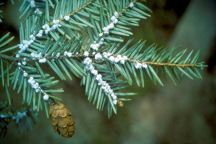
| Hemlock woolly adelgids on eastern hemlock. Photo by Justin Williams, UNH/EOS. |
“For this project to be successful we really needed relevant ground data, so we went to 110 randomly placed points—each point being 30 by 30 meters or the equivalent of one Landsat image pixel—throughout the study region and looked at the percent of hemlock and surveyed for the pest,” Williams says. “This gave us our reference data from which we were able to build our hemlock habitat model.”
The ground-based reference data also allowed them to attempt a Landsat data classification in order to zero in on high-value, high-density hemlock stands. But, Williams notes, the classification based on the percentage of hemlock wasn’t nearly as robust as the classification based on whether or not the pest was present. “So it was at that point we realized that the reflectance differences we observed under laboratory conditions were also being recorded in the satellite data.”
Just why infested needles contain greater amounts of the photosynthetic pigment chlorophyll is a mystery.
Says Williams, “It’s a really interesting question that we are still debating. Is this a compensatory response by hemlock? That is, even with initial, modest defoliation by the pest there would be fewer needles and therefore the trees could increase photosynthetic capacity in the remaining needles. Another possibility could be it has something to do with the feeding mechanisms of the hemlock woolly adelgid itself—perhaps there’s something enzymatic within the needles that’s happening. That’s all just hypothetical; we can’t determine ‘the why’ based on our data.” He adds, “When you conduct research, many times you end with more questions than answers, and that is what propels the science forward.”
Ahead of the damage curve
Williams’ research has indeed propelled work in this area forward and it is his hope that it will eventually lead to formal procedures that could help lessen the damage wrought by the hemlock woolly adelgid.
“This work was done with the Forest Service and they’d really like to see a set of protocols that they can use or that can be given to state agencies as a way to empower these agencies to do it themselves. The significance of this work is early detection; we want to know where this pest is before large-scale infestation and damage occurs so that we can initiate management decisions that might reduce future damage.”
Since early detection has been and still is mostly boots-on-the-ground surveying, the newfound remote sensing technique could become a very powerful and cost-effective tool.
 |
|
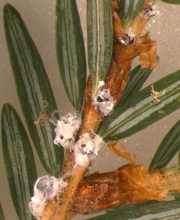
| Adult hemlock woolly adelgids on hemlock branches. The aphid-like insect covers itself and its eggs with a white, waxy "wool" that acts as a protective coating. Photo by Justin Williams, UNH/EOS. |
“It could save a lot of time, money, and effort,” Williams notes. But he adds that before the methodology can be rolled out for widespread use, more study would need to be done to determine if his master’s project work is repeatable and can be expanded to other regions with different topography and diversity of trees. Overall, he says, the project served as a good pilot study.
“At some point I’d like to continue this research. I love the fieldwork and data analysis aspects of what we do in terms of forestry and natural resource management. In addition, using satellites and other technologies to look at how things are happening at the landscape scale is a unique skill set and it really makes the work more fun and interesting.”
But Williams thinks it unlikely he’ll be able to take the next step with the adelgid/remote sensing work unless funds are made available, which, he says, “I don’t think is in the cards right now.”
And going for a doctorate is also not in the cards at the moment for Williams.
“I have entertained thoughts about going for a Ph.D., but I’ve now been in school for nine years and so I’m looking forward to a bit of an academic break,” he says. “You can learn a lot in the classroom and a lot through your research program as a graduate student, but I feel that gaining some real-world experience and developing relationships with other professionals is really important at this point.”
As Spheres goes to press, Williams reports he’s just landed a job with the U.S. Forest Service Southern Research Station in Starkville, Mississippi.
"As a research forestry technician, I'll be working with scientists on a project that studies the annual variation in bottomland oak species reproduction," he says adding, "and my remote sensing and GIS skills will be put to work through spatial analysis and mapping."